The best source for finding and planning your walk, hike or tramp in New Zealand.
Choose from over 3,000 tracks, huts and campsites across Aotearoa. Whether you’re looking for a short walk, a day walk or an overnight tramp, Plan My Walk has everything you need to plan safe and successful outdoor adventures in New Zealand.
Head to the Plan My Walk website
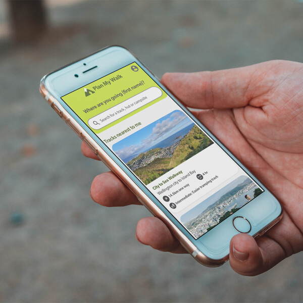
Plan My Walk makes it easy to find your next adventure and get all the information you need to plan a safe and successful trip. With New Zealand’s largest database of public tracks, huts and campsites, it’s easy to plan a trip by searching the name of the track, hut or campsite, using the map, or applying filters. Once you’ve chosen a trip, you’ll have access to all the information you need, such as:
- Detailed descriptions of tracks, huts and campsites
- Maps of the area, including LINZ Topo and satellite maps
- Track alerts, provided by the Department of Conservation and local councils
- Weather forecasts, warnings and watches, provided by MetService
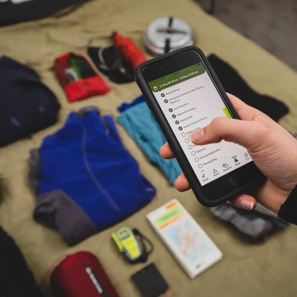
- Interactive and customisable gear lists
- Track, hut and campsite reviews and photos from Plan My Walk’s outdoor community, including star ratings and tags highlighting safety tips and key features.
Register for Free and Access More Features
Plan My Walk is free to use, but by creating a free account, you get access to additional features.
Creating a free account allows you to:
- Save tracks to your wishlist
- Easily and quickly create trip plans and share these with your trusted emergency contact
- Receive updates and alerts about your trip plan, such as newly issued weather warnings
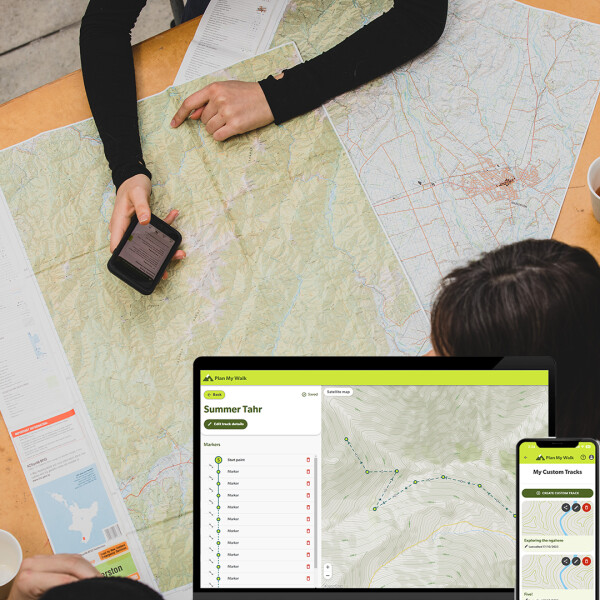
- Create custom tracks for off-track adventures or grouping existing tracks for your own personalised trip
- Build custom gear lists and save these for future trips.
How to Plan a Trip on Plan My Walk
Find a track: If you're not looking for a specific track, you can search using the filters or the map view. You can find tracks based on location, difficulty, duration, distance, dog-friendly status, and much more using the search filters. You can also build your own custom track if what you're looking for isn't already on the database.
Check for track alerts: This is essential information about a track’s status, such as if a track has been closed or weather warnings have been issued for the area.
Learn about the track, hut or campsite: Get essential information, including how to get there, facilities and what to expect.
Read user reviews: Genuine experiences from the Plan My Walk outdoor community, with photos, star ratings and useful tags to get a first-hand account of the track, hut or campsite.
Check the track-specific weather forecasts and warnings provided in partnership with MetService, NZ’s official public weather forecast provider.
Create trip gear lists by customising a suggested gear list or building your own list from scratch. Save your custom gear lists to your profile for future use.
Complete the easy trip planner and share it with your group and emergency contact.
Watch safety videos: Award-winning tramping safety videos and Virtual Track Guides on a selection of New Zealand’s most popular tramps and hikes.
The Plan My Walk app, our free trip planning tool, can now be accessed via satellite by both One NZ and Spark customers who have an eligible phone and supported plan. Find out more about this service on our Plan My Walk webpage. The services apply to TXT and satellite-enabled apps only. Phone calls, browsing the internet and data outside of specific satellite-enabled apps are not available.For example, you can use the Plan My Walk app to find track and other information, but you can’t browse our webpages or use our social media channels. You must have line of sight to the sky for the service to work as your phone needs to connect to orbiting satellites.Obstructions from tree branches, steep sided gullies or human-made features that restrict your view of the sky will impact your connectivity. Text messages are unlikely to send or be received instantly. In many cases TXT messages will take a couple of minutes or more as messages travel via the satellite network. For full details on the satellite to mobile services, visit the One NZ or Spark websites.
How satellite service work
App Updates
Updated: December 2025 Plan My Walk is now easier to use for everyone, with improvements for people using screen readers and those with visual impairments, including colour blindness. Plus, other enhancements for a superior user experience! The custom track builder allows users to simply and effectively create their own custom track, and still get all the benefits of Plan My Walk, such as track alerts, weather warnings and forecasts, gear lists and more. Users can drop pins on a map to create their own walking track anywhere in New Zealand. Custom Tracks are perfect for: Users can create, name and customise their own gear lists to suit their adventure needs. Custom Gear Lists are perfect for:
Rate and tag your trips
Highlights pages make it easier to explore
More map views
Enhanced accessibility
Plan a Trip to a Hut or Campsite, Just As You Would for a Track
Improved Functionality
Custom Tracks
Custom Gear

Are you travelling in New Zealand and looking for other helpful resources or guidance to make the most of your stay? Take a look at the Tiaki Promise.
Questions about Plan My Walk? Visit the FAQ page, or contact us at info@mountainsafety.org.nz.