Places to Explore | Circle Track
The Circle Track is the perfect half-day walk if you’re looking for a less-travelled adventure near Te Anau or Manapouri!
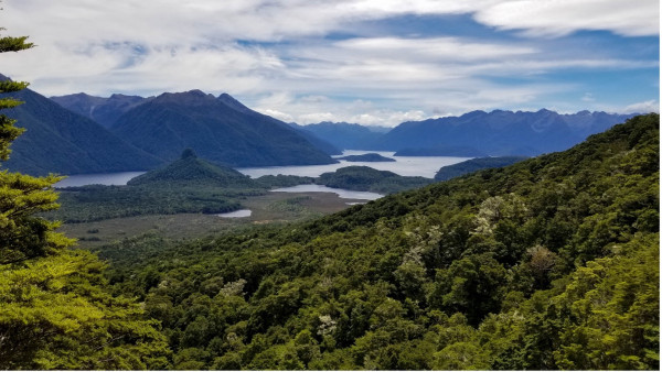
Guest Story from Fiordland DOC Ranger, Merissa Strawsine | Cover image: The Hunter Mountains, including Mount Titiroa, as seen from the Circle Track. DOC/Taylor Barron
Before embarking on your adventure, you’ll need to arrange transport across the Waiau River from the Pearl Harbour boat ramp at the southern edge of Manapouri (20min drive from Te Anau) to the start of the track. If you don’t have a kayak or packraft of your own, you can hire boat transport with water taxis that are available during the summer season.
Once you’ve arrived at the jetty on the other side of the river the real adventure begins! This 6.9km (3-4 hour) loop track begins with a flat 15-minute walk along the riverside to the loop junction. Here it is recommended to go left (clockwise) and tackle the steepest part of the track first for easier navigation. It is an advanced tramping track, so although the track is clearly marked, it is important to keep an eye out for the orange track markers that can often be obscured by dense bush and treefall. The steep and often muddy climb up takes you through mixed beech and podocarp forest that rewards you with the songs of native birds (robins, tomtits, tūī and bellbirds) and buzzing cicadas.
After completing the 356m climb, you’ll arrive at a sign leading you to the main viewpoint. Use caution when navigating this section and refrain from getting close to the edge, as the cliff face is eroding and may be unstable. You’ll notice several breaks in the trees that give way to stunning views, starting with a panoramic view of the Hunter Mountains, including the impressive Mount Titiroa. Rising 1,715m above sea level, Mt. Titiroa appears white year-round due to granite remains of an ancient magma chamber. This peak also notoriously contains many oddly shaped boulders due to the unique exfoliation of the rock.

View of Lake Manapouri, with the Monument visible in the lower left, and Rona Island in the distance to the right. Photo credit: DOC/Merissa Strawsine
Looking further to the right you’ll also get great views overlooking Lake Manapouri, which is not only New Zealand’s second deepest lake, but also home to the country’s most famous environmental battle. In the 1970s activists fought to keep the lake levels from being raised 30m to harness the hydroelectric power of the region. The original proposal would have drowned many of the lake’s islands as well as the town of Manapouri and Te Anau. However, due to public outcry and a petition signed by nearly 10% of New Zealanders, the project was halted after the construction of the power station. Thanks to the action of these environmental activists, today you can enjoy views of Manapouri’s many islands, including Rona Island which is home to Haast tokoeka kiwi as a “creche” location for them to grow big and strong protected from introduced predators by a local trapping programme.
After you’ve spent enough time soaking in the view, make your way back to the main track and descend the ridgeline to the junction with the Hope Arm Track. To complete the Circle Track, turn right at the junction and follow the track for another hour to return to the jetty. On the way back, the track follows the shoreline of Lake Manapouri and you’ll have multiple opportunities to go down to the beach for a swim in nice weather.
If you’d like to explore this area more, you can combine the Circle Track with the Hope Arm or Back Valley Hut tracks for an overnight adventure and even visit both huts as part of a 6-7 hour loop.
So if you're heading to the stunning Fiordland National Park, make sure you have a look around at the fantastic options available as both shorter and longer walks, there is something for everyone!
- Read about Mt Burns, a nearby destination for walkers
- Download the free Plan My Walk app or consult the Land Safety Code for tips on how to prepare and what to pack.