Places to explore | Mt Burns
Looking for a less-crowded alpine walk in Fiordland? Look no further! The walk to the Mount Burns Tarns is a short but challenging walk which rewards you with alpine grandeur.
Guest Story from Fiordland DOC Ranger, Merissa Strawsine | Cover image: The Mount Burns tarns with the mountains across the Grebe Valley in the distance. (C. Brindle, DOC)
The journey to this less-travelled corner of Fiordland National Park begins on the Borland Road, north of Lake Monowai. This 4WD gravel road was originally established for the construction of the Manapouri Hydro Station and winds its way up to Borland Saddle (990m) where you will park to begin your walk up to the tarns.
While this advanced tramping track is only 1km (45min return), it quickly starts with a steep climb through forest dominated by the iconic Fiordland canopy species Lophozonia menziesii (tawhai/silver beech). Take extra care when navigating this part of the track to avoid exposed roots and windfall. After only about 10 minutes you emerge out of the bush with views of the sharp treeline on the mountains across the Grebe Valley. In this area, the treeline appears around 1000m and is a common temperature-driven phenomenon, varying with aspect and temperature.
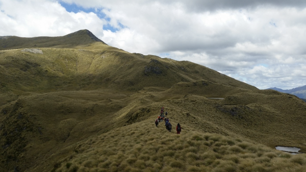
The climb continues through alpine tussockland that contains the most diverse range of snow tussock species in New Zealand. While this ecosystem is dominated by Chionochloa teretifolia (Terete-leaved snow tussock), it is extremely diverse and is also one of the most “botanized” areas of Fiordland! The exceptional diversity is due to the unique environmental conditions, as it is where the drier Southland and Otago climates intersect with the wetter western Fiordland climate. Here, there are nearly 300 species of native plants, including a variety of alpine daisies, speargrasses, gentians, buttercups, hebes, and much more. At the end of the track, you are met by the beautiful alpine tarns nestled amongst the golden tussocks, with views of Island and Green Lakes in the distance.
After exploring the tarns, you can turn around and head back to the carpark at Borland Saddle or continue beyond the tarns to climb Mount Burns. This challenging steep climb is approximately 10km (6-7hrs return). However, the route is not marked, so be sure you are properly equipped and have sound navigational skills. If you’d like to explore this amazing area further, consider venturing out to Green Lake Hut as an overnight tramping trip, or for a difficult walk you can tackle the Eldrig Peak Route.

Golden rolling tussocks, typical of the Mount Burns area. Photo: DOC
Whether you go to the tarns or to the top of Mount Burns, this walk is a great opportunity to slow down and take your time exploring the rich plant life (and also a great excuse to catch your breath on those steep uphill sections!). But remember that this is a fragile alpine area that contains several species endemic to Fiordland and over a dozen others that are nationally threatened. So please stick to the track where you can and tread carefully!
2022 Event
If you’d like to learn more about this unique alpine ecosystem, you can sign up for DOC’s “Discover the Alpine World” guided walk led by DOC botanist Brian Rance on January 15th 2022. At this event you’ll walk along the Mount Burns tops and learn about the amazing adaptations of the plants that live in this environment.
Things to know:
- The best time to attempt the track is in the summer months between November and March.
- The Borland Road is unsealed, narrow and steep in places, and subject to slips, washouts, snow, ice, high winds and fallen trees. Always check the DOC webpage beforehand for alerts/closures along the road.
- The road is suitable for 4WD and some other vehicles depending on conditions. However, it is not suitable for campervans, caravans or trailers.
- There is no fuel, communication (including cell phone coverage) or emergency services along the road, therefore only those properly equipped should attempt to negotiate the road.
- Go prepared for all weather conditions. You can download the free Plan My Walk app or consult the Land Safety Code for tips on how to prepare and what to pack.